But there is no river on Rapa Nui. Indeed, Easter Island has no perennial watercourse of any kind. Perhaps there were streams prior to deforestation but, by any estimation, water resources were and are a major issue for inhabitants of this small remote island with irregular rainfall. That and other environmental limitations make the erection of the famous statues (moai) on their even larger platforms (ahu) all the more impressive and mysterious.

An interesting new study highlighted by CNN in this linked story claims to have solved “the mystery” of why Rapa Nui (Easter Island)’s ahu and moai were built where they were. In the technical article (online version here for the academically interested),[1] a team of scholars concludes that the island’s famous structures were built at locations where fresh water was available. In some ways this seems like an obvious solution, but the study employs GIS and statistics to solidify the case. The authors include Terry Lipo and Carl Hunt, who acknowledge the environmental stress and deforestation realities but rightly emphasize the ingenuity of the Rapanui people in their excellent 2011 book.[2]
This addition to my series on Rapa Nui/Easter Island is to call attention to this important study and allow me to add a related personal anecdote.

As an archaeologist with a desire to see everything everywhere, I naturally sought to visit as many of the 200-300 ahu as possible on a 5-day visit to Rapa Nui. Most tourists and bus tours concentrate on the well-known sites with restored ahu and re-erected moai, or the half-buried “heads” of moai at the Rano Raraku quarry. We saw those, but I dragged my long-suffering wife to many other ruins that appear to be “piles of rocks.”

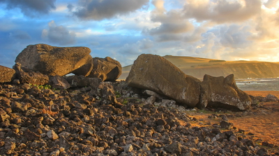
At the relatively unimpressive and little-visited Ahu Hanga Tetenga on the SE coast, I noticed a fenced cattle pasture across the road as I turned down the trail to the site. Exiting our rental “jeep” (a 4×4 Suzuki Jimny) I anoticed a pronounced droning noise mixed with the sound of the surf. But attracted by the ruins, I ignored all this and headed for the pile of rocks that once was a proud ahu with two toppled and broken moai.

I gawked and photographed as Felicia admired the South Pacific. Suddenly the droning noise ceased and, within a minute, a lone motor scooter careened down the slope from the cattle yard above and beyond the road — headed straight for my wife! The rider dismounted as I walked swiftly and warily that direction. He passed Felicia without a word and bounded down the short cliff to the water, where I was able to crane and see a gas-powered water pump that had quit. He retrieved a hidden gas can, added fuel, and restarted it. Passing us without comment, he jumped on the scooter and bounced away over the rocky landscape to tend his cattle. Unbelievably, it did not occur to me to photograph the pump system or the rancher who was there less than two minutes. His water pipe is faintly visible here:

I remembered commenting to Felicia as we turned down the path, “I wonder how they get enough water for those cattle in this desolate place?” Now we knew. The rancher was pumping from a “seep,” where the fresh water aquifer of the island invisibly spills out of the submerged rocks into the ocean. Such seeps are common and long-utilized on Rapa Nui. The location of Ahu Hanga Tetenga, just above this source, vividly demonstrates the study’s conclusions.

The article, just published last week (10 January 2019) not only presents a reasonable and well-defended case, but it is also a model of “open access” publishing (meaning that it is available to anyone without subscription). The authors even provide links to shapefiles (GIS data) used in the research. I happily downloaded and incorporated them to improve my own data and map of Rapa Nui (above). Now I have a need to go back to get a pic of that pump . . .
Thanks for looking! ![]() (read the footnotes)
(read the footnotes)
[1] R. J. DiNapoli, C. P. Lipo, T. Brosnan, T. L. Hunt, S. Hixon, et al. 2019. Rapa Nui (Easter Island) monument (ahu) locations explained by freshwater sources. PLOS ONE 14(1): e0210409. https://doi.org/10.1371/journal.pone.0210409.
[2] Terry Hunt and Carl Lipo, Carl. The Statues that Walked: Unraveling the Mystery of Easter Island (New York: Free Press, 2011).